


Britons currently weathering some sub-standard conditions have been told to sit tight for just two more weeks – with temperature maps turning red for the start of July hinting that summer might finally be here.
Data from forecasters MetDesk has indicated that the inclement climes plaguing the country will continue for rest of June, with thermometers barely passing the 20C mark over the final 14 days of the month.
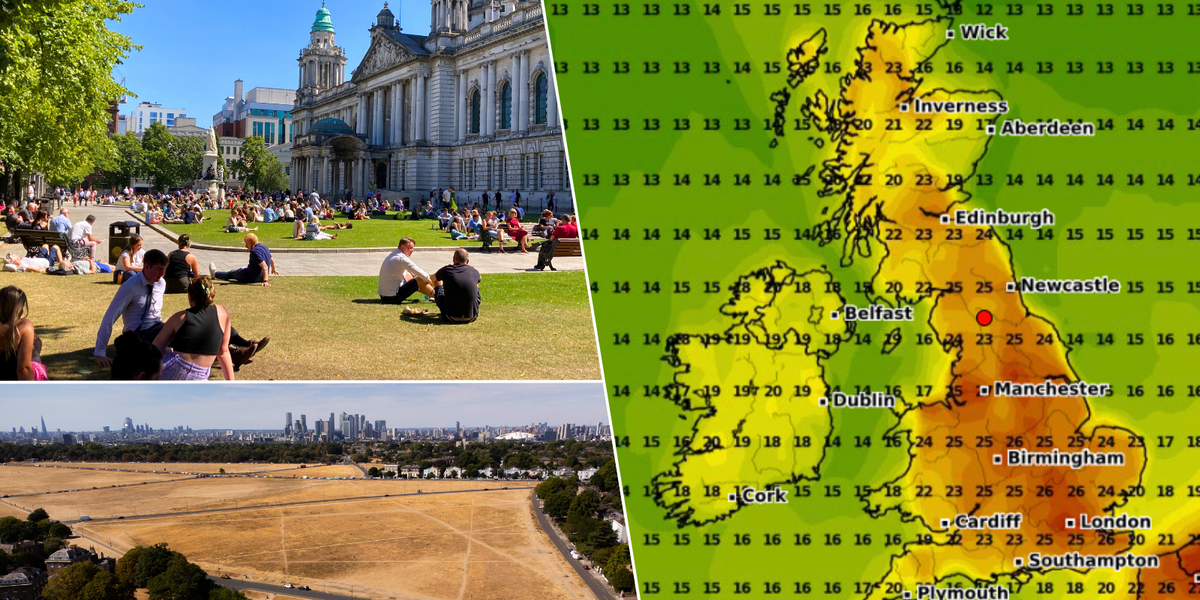
Over the next week, only London and the South will experience temperatures in the 20s with much of the UK set for averages in the low teens ahead of the weekend.
And while the week after will see more of the Midlands and the North hitting the low 20s, it remains a fairly dire outlook across the country – with parts of Scotland, Wales and Northern Ireland barely crossing 15C in the next 10 days.
Weather maps have turned red for July 1 with swathes of the UK set to bask in high twenties heat
PA/WXCharts
But it’s not all bad – more MetDesk data for the end of June sees weather maps in England, Scotland and Wales turning orange, with North Wales, Merseyside, Birmingham and Leeds all approaching 25C.
And on July 1 – 11 days after summer officially begins – Britain is finally slated to bask under some seasonal heat.
Maps across the country will turn red as temperatures average out in the mid-to-high 20s – with London, Leeds and Manchester leading the way as thermometers pass 26C.
The news of a sweltering start to July comes as the same forecasters at MetDesk have pegged parts of Northern England to endure temperatures as low as 3C.
MORE UK WEATHER NEWS:
Things are finally heating up as Britain enters July (file photo)
PA
In their model for June 29, WXCharts has forecast that the temperature will fall to 3C in Newcastle.
Those in Aberdeen and Inverness will also have to put their summer wardrobes on hold and wrap up warm – as the mercury is expected to plunge to between 3C and 4C.
The Met Office’s long-range forecast for the end of June warns of an area of cloud edging northwestwards from Europe and bringing a couple of days of thundery rain and hot and humid conditions to the southeast.
While Into the last week of June, the Met Office says, “changeable conditions” are likely, with the focus for these conditions being across the north and west, with spells of more settled and drier conditions likely in the south and east.
Later on, the Met Office’s long-range predictions for the start of July says: “There is little sign for any one type of weather pattern to dominate during this period.
“As such, typical conditions for the UK are most probable with a mixture of weather types.
“All areas can expected to see some spells of drier, sunnier weather, but there will also be showers or longer spells of rain at times.
“Currently the only signals, weak as they are, hint that rain and showers will tend to be more biased towards the north and west, with any more prolonged drier interludes favouring the south.”


